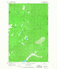
1965 Map of Nelson Peak
USGS Topo · Published 1967About this map
Colville National Forest and Kaniksu National Forest converge in this mid-1960s topographic survey of the Stevens and Pend Oreille county line. The landscape is defined by significant elevations, including Nelson Peak, Benson Peak, and Bald Mountain, with a series of small, isolated mountain lakes such as Buzzard Lake, Nelson Lake, and Benson Lake dotting the drainages. A network of primitive transportation routes, including the Upper Cottonwood Road and various unnamed jeep trails, provide access to higher ground and localized prospects indicating mineral exploration. In the lower elevations, water features like Deer Lake and the marshy expanses of Betts Meadows and Woodward Meadows characterize the transition from timbered slopes to basin floors. Cultural landmarks are sparse but specific, including Camp Hafer and the Kaniksu Ranch, showing the modest footprint of settlement and recreation in this heavily forested mountain region.
Find a feature on this map
23 named features on this map. Tap any name to fly to it.
Don’t see what you’re looking for? This feature index may not catch every label — zoom into the map to look around manually.
Map Details
Editions of this 1965 Nelson Peak Map
Other maps of this area

1927 · Chewelah
USGS Topo · 1:125,000

1930 · Chewelah
USGS Topo · 1:125,000

1936 · Newport
USGS Topo · 1:96,000

1942 · Newport
USGS Topo · 1:125,000

1958 · Sandpoint
USGS Topo · 1:250,000

1963 · Sandpoint
USGS Topo · 1:250,000

1964 · Chewelah
USGS Topo · 1:24,000

1964 · Goddards Peak
USGS Topo · 1:24,000

1964 · Chewelah Mtn
USGS Topo · 1:62,500
1965 · Valley
USGS Topo · 1:24,000