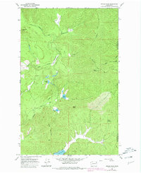
1965 Map of Nelson Peak
USGS Topo · Published 1981About this map
Nelson Peak and Benson Peak dominate the topography of this mountainous portion of the Selkirk range along the border of Stevens and Pend Oreille counties. The landscape is characterized by high-elevation meadows and remote summits, connected by primitive infrastructure such as the Upper Cottonwood Road and the Divide Road. The 1970s revisions to this mid-century survey reveal a territory defined by seasonal occupation and specialized land use, centered around sites like Camp Hafer and Kaniksu Ranch. Water resources are abundant in the high basins, with Deer Lake to the south and a series of smaller alpine bodies including Nelson Lake, Benson Lake, and Buzzard Lake. Numerous Prospect and Prospects labels indicate a history of mineral exploration throughout the Cottonwood Creek and Grouse Creek drainages.
Find a feature on this map
25 named features on this map. Tap any name to fly to it.
Don’t see what you’re looking for? This feature index may not catch every label — zoom into the map to look around manually.
Map Details
Editions of this 1965 Nelson Peak Map
Other maps of this area

1927 · Chewelah
USGS Topo · 1:125,000

1930 · Chewelah
USGS Topo · 1:125,000

1936 · Newport
USGS Topo · 1:96,000

1942 · Newport
USGS Topo · 1:125,000

1958 · Sandpoint
USGS Topo · 1:250,000

1963 · Sandpoint
USGS Topo · 1:250,000

1964 · Chewelah
USGS Topo · 1:24,000

1964 · Goddards Peak
USGS Topo · 1:24,000

1964 · Chewelah Mtn
USGS Topo · 1:62,500
1965 · Valley
USGS Topo · 1:24,000