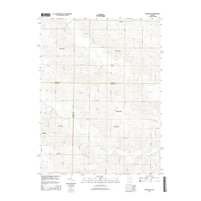
2014 Map of Nelsonville
USGS Topo · Published 2014About this map
Nelsonville sits at the heart of this rural landscape where the boundaries of Marion, Lewis, and Shelby counties converge. The terrain is defined by the winding course of the South Fabius River and several significant tributaries, including Troublesome Cr and Allen Br. This 2014 edition documents a region of small farm-to-market settlements, showing Argola to the north and Sigsbee to the southwest, connected by a network of county roads such as Co Road 104 and Shelby 174. Several small water bodies carry family names, such as Doctor Wells Lake, Loscher Lake, and Doscher Brothers Lake, suggesting a long-standing local connection to the land. The presence of the Methodist Cemetery near the Shelby County line provides a tangible link for those researching family history in this quiet agricultural corner of Northeast Missouri.
Find a feature on this map
67 named features on this map. Tap any name to fly to it.
Don’t see what you’re looking for? This feature index may not catch every label — zoom into the map to look around manually.
Map Details
Editions of this 2014 Nelsonville Map
This is the sole edition of this map. No revisions or reprints were ever made.
Other maps of this area

1903 · Kahoka
USGS Topo · 1:125,000

1903 · Palmyra
USGS Topo · 1:125,000

1948 · Quincy
USGS Topo · 1:250,000

1949 · Durham
USGS Topo · 1:24,000

1949 · Philadelphia
USGS Topo · 1:24,000

1950 · Durham
USGS Topo · 1:24,000

1950 · Philadelphia
USGS Topo · 1:24,000

1950 · Lewistown
USGS Topo · 1:24,000
1950 · Monticello
USGS Topo · 1:24,000

1950 · La Belle
USGS Topo · 1:24,000