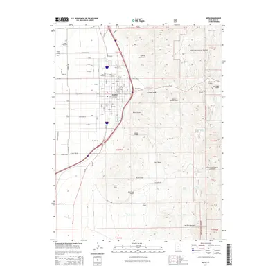
2014 Map of Nephi
USGS Topo · Published 2014About this map
Nephi serves as the central hub of this Juab County landscape, where the flatlands of Long Valley meet the rising slopes of the Wasatch Range and the San Pitch Mountains. The town's grid is well-defined, transitioning from residential streets into a significant industrial and transport network. Local history is anchored at the Vine Bluff Cem and Nephi City Cem, while the Gypsum Mill east of the city center points to the area's mineral-based industry.
Find a feature on this map
93 named features on this map. Tap any name to fly to it.
Don’t see what you’re looking for? This feature index may not catch every label — zoom into the map to look around manually.
Map Details
Editions of this 2014 Nephi Map
This is the sole edition of this map. No revisions or reprints were ever made.
Other maps of this area

1885 · Manti
USGS Topo · 1:250,000

1895 · Manti
USGS Topo · 1:250,000

1951 · Moroni
USGS Topo · 1:62,500

1951 · Santaquin
USGS Topo · 1:62,500

1951 · Nephi
USGS Topo · 1:62,500

1952 · Santaquin Peak
USGS Topo · 1:62,500

1956 · Price
USGS Topo · 1:250,000

1960 · Price
USGS Topo · 1:250,000

1962 · Price
USGS Topo · 1:250,000
1979 · Slate Jack Canyon
USGS Topo · 1:24,000