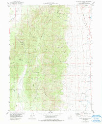
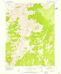
1979 Map of Slate Jack Canyon
USGS Topo · Published 1979About this map
Long Ridge dominates the center of this landscape, serving as a high divide between the broad basins of Goshen Valley to the northwest and Juab Valley to the east. This 1970s survey captures a transition zone defined by essential water sources and rugged relief, including the drainage of Slate Jack Canyon and the named water holes critical for regional livestock and wildlife, such as State Jack Spring, Cottonwood Spring, and Lunt-Lattimer Spring. The eastern edge is anchored by the Mona Reservoir, with the Goshen Canyon Road providing the primary transit corridor through the northern gap. Evidence of human enterprise is scattered throughout the terrain, from prospecting sites and a Mine on the northern slopes to the distinctive landmark of The Devils Stairs in the southwest, reflecting a history of small-scale mineral exploration and ranching typical of this part of the state.
Find a feature on this map
34 named features on this map. Tap any name to fly to it.
Don’t see what you’re looking for? This feature index may not catch every label — zoom into the map to look around manually.
Map Details
Editions of this 1979 Slate Jack Canyon Map
This is the sole edition of this map. No revisions or reprints were ever made.
Other maps of this area

1885 · Manti
USGS Topo · 1:250,000

1885 · Sevier Desert
USGS Topo · 1:250,000

1895 · Manti
USGS Topo · 1:250,000
1949 · Eureka
USGS Topo · 1:24,000
1951 · Santaquin
USGS Topo · 1:62,500
1951 · Nephi
USGS Topo · 1:62,500

1953 · Delta
USGS Topo · 1:250,000
1954 · Tintic Mountain
USGS Topo · 1:24,000
1954 · Eureka
USGS Topo · 1:24,000

1956 · Price
USGS Topo · 1:250,000