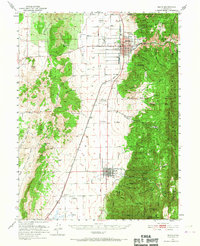
1951 Map of Nephi
USGS Topo · Published 1967About this map
Nephi sits at the base of the Wasatch Range, serving as a central hub for Juab County during the mid-century. The landscape is defined by the sharp transition between the valley floor and the high peaks of the Uinta National Forest, where steep canyons like Andrews Canyon and Biglows Canyon drain toward the settlements below. This 1951 survey illustrates a well-developed civic infrastructure, including the Nephi Municipal Airport, the County Fairgrounds, and the Nephi Power Plant. The presence of the Utah Agriculture Experiment Station near Levan reflects the era's focus on scientific land management and local cultivation.
Find a feature on this map
67 named features on this map. Tap any name to fly to it.
Don’t see what you’re looking for? This feature index may not catch every label — zoom into the map to look around manually.
Map Details
Editions of this 1951 Nephi Map
4 editions found
Other maps of this area

1885 · Manti
USGS Topo · 1:250,000

1885 · Sevier Desert
USGS Topo · 1:250,000

1895 · Manti
USGS Topo · 1:250,000

1951 · Moroni
USGS Topo · 1:62,500

1951 · Santaquin
USGS Topo · 1:62,500

1951 · Nephi
USGS Topo · 1:62,500

1952 · Scipio North
USGS Topo · 1:62,500

1952 · Santaquin Peak
USGS Topo · 1:62,500

1953 · Delta
USGS Topo · 1:250,000

1954 · Tintic Mountain
USGS Topo · 1:24,000