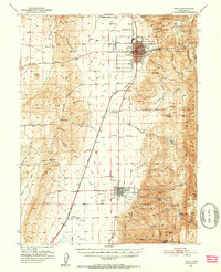
1951 Map of Nephi
USGS Topo · Published 1953About this map
The Union Pacific railroad corridor serves as the central artery through this 1951 survey of the Juab Valley, linking the primary settlements of Nephi and Levan. Industrial activity is concentrated at the canyon mouths of the Wasatch Range, where the Nephi Power Plant and a Gypsum Mill highlight the era's local utility and resource extraction. The map captures the agricultural infrastructure of the mid-century, noting the Utah Agriculture Experiment Station and the Nephi Municipal Airport north of town. For genealogists and local historians, the sheet provides precise locations for Vine Bluff Cem and the small siding at Juab. To the east, the terrain rises sharply into the Uinta National Forest, marked by numerous named canyons like Andrews Spring Canyon and recreational spots such as Chicken Creek Camp, illustrating the transition from the valley's managed irrigation canals to the wilder high country.
Find a feature on this map
79 named features on this map. Tap any name to fly to it.
Don’t see what you’re looking for? This feature index may not catch every label — zoom into the map to look around manually.
Map Details
Editions of this 1951 Nephi Map
4 editions found
Other maps of this area

1885 · Manti
USGS Topo · 1:250,000

1885 · Sevier Desert
USGS Topo · 1:250,000

1895 · Manti
USGS Topo · 1:250,000

1951 · Moroni
USGS Topo · 1:62,500

1951 · Santaquin
USGS Topo · 1:62,500

1951 · Nephi
USGS Topo · 1:62,500

1952 · Scipio North
USGS Topo · 1:62,500

1952 · Santaquin Peak
USGS Topo · 1:62,500

1953 · Delta
USGS Topo · 1:250,000

1954 · Tintic Mountain
USGS Topo · 1:24,000