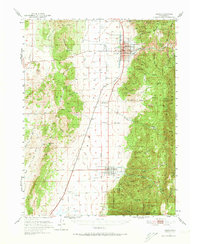
1951 Map of Nephi
USGS Topo · Published 1973About this map
Nephi serves as a significant central corridor in the early 1950s, where the Union Pacific railroad and U S 91 run parallel through the valley floor. The map illustrates a highly organized agricultural and civic landscape, featuring the Utah Agriculture Experiment Station and the Nephi Municipal Airport north of the town center. To the east, the terrain rises sharply into the Uinta National Forest, defined by deep drainages like Salt Creek and Andrews Canyon.
Find a feature on this map
57 named features on this map. Tap any name to fly to it.
Don’t see what you’re looking for? This feature index may not catch every label — zoom into the map to look around manually.
Map Details
Editions of this 1951 Nephi Map
4 editions found
Other maps of this area

1885 · Manti
USGS Topo · 1:250,000

1885 · Sevier Desert
USGS Topo · 1:250,000

1895 · Manti
USGS Topo · 1:250,000

1951 · Moroni
USGS Topo · 1:62,500

1951 · Santaquin
USGS Topo · 1:62,500

1951 · Nephi
USGS Topo · 1:62,500

1952 · Scipio North
USGS Topo · 1:62,500

1952 · Santaquin Peak
USGS Topo · 1:62,500

1953 · Delta
USGS Topo · 1:250,000

1954 · Tintic Mountain
USGS Topo · 1:24,000