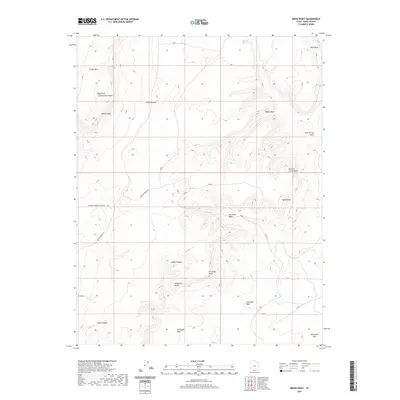
2020 Map of Nephi Point
USGS Topo · Published 2020About this map
White Cliffs and the northern edges of the Vermilion Cliffs dominate this high-desert landscape in southern Utah. The terrain is defined by a series of prominent drainages, including Nephi Wash, Deer Spring Wash, and Kitchen Corral Wash, which cut through the uplifted plateaus. Human presence is sparse, centered on the Nephi Pasture Rd which provides access to the Nephi Pasture and several family-named landmarks like Nephi Point. This 2020 survey illustrates the complex erosion patterns between Timber Mtn and the southern Telegraph Flat, showing how water has carved numerous side canyons such as Ladder Canyon and Snake Canyon into the multi-colored geological layers. Traditional water sources like Wildcat Spring remain critical features in this arid environment.
Find a feature on this map
20 named features on this map. Tap any name to fly to it.
Don’t see what you’re looking for? This feature index may not catch every label — zoom into the map to look around manually.
Map Details
Editions of this 2020 Nephi Point Map
This is the sole edition of this map. No revisions or reprints were ever made.
Other maps of this area

1886 · Kanab
USGS Topo · 1:250,000

1953 · Cedar City
USGS Topo · 1:250,000

1954 · Buckskin Gulch NW
USGS Topo · 1:24,000

1954 · Buckskin Gulch NE
USGS Topo · 1:24,000

1954 · Buckskin Gulch SE
USGS Topo · 1:24,000

1954 · Buckskin Gulch SW
USGS Topo · 1:24,000

1954 · Johnson SE
USGS Topo · 1:24,000

1954 · Johnson NE
USGS Topo · 1:24,000

1954 · Buckskin Gulch
USGS Topo · 1:62,500

1954 · Johnson
USGS Topo · 1:62,500