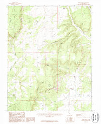
1987 Map of Nephi Point
USGS Topo · Published 1987About this map
The Vermilion Cliffs and White Cliffs dominate this 1980s landscape in Kane County, defining a region of stark geological benches and deep-cut drainages. This provisional survey captures the area as it was documented through mid-decade field checks, showcasing a network of seasonal water sources and canyons that dictate movement through the high desert. Prominent landforms like Timber Mountain and the expansive Nephi Pasture indicate the grazing and timbering potential that historically drew people to these remote plateaus.
Find a feature on this map
17 named features on this map. Tap any name to fly to it.
Don’t see what you’re looking for? This feature index may not catch every label — zoom into the map to look around manually.
Map Details
Editions of this 1987 Nephi Point Map
This is the sole edition of this map. No revisions or reprints were ever made.
Other maps of this area

1886 · Kanab
USGS Topo · 1:250,000

1953 · Cedar City
USGS Topo · 1:250,000

1954 · Buckskin Gulch NW
USGS Topo · 1:24,000

1954 · Buckskin Gulch NE
USGS Topo · 1:24,000

1954 · Buckskin Gulch SE
USGS Topo · 1:24,000

1954 · Buckskin Gulch SW
USGS Topo · 1:24,000

1954 · Johnson SE
USGS Topo · 1:24,000

1954 · Johnson NE
USGS Topo · 1:24,000

1954 · Buckskin Gulch
USGS Topo · 1:62,500

1954 · Johnson
USGS Topo · 1:62,500