
1968 Map of Neponset Reservoir NE
USGS Topo · Published 1971About this map
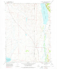
The Bear River meanders across the state line in this late-1960s survey of the high desert borderlands between Rich County, Utah, and Uinta County, Wyoming. This arid landscape is defined by its complex irrigation infrastructure, showing how water was diverted through the Chapman Canal, Crompton Ditch, and the engineering of the Christensen Tunnel. Major water bodies including the Woodruff Narrows Reservoir and the Neponset Reservoir dominate the hydrology of the area, providing critical storage for local ranching and agricultural efforts. Intermittent drainages like Dry Creek and seasonal flows from Whitney Canyon Creek underscore the importance of the permanent Spring sites and man-made reservoirs. The terrain is marked by family-named landmarks such as Acocks Can and Christensen Hollow, alongside several Gravel Pit and Borrow Pit operations that suggest local infrastructure development during this period.
Find a feature on this map
23 named features on this map. Tap any name to fly to it.
Don’t see what you’re looking for? This feature index may not catch every label — zoom into the map to look around manually.
Map Details
Editions of this 1968 Neponset Reservoir NE Map
2 editions found
Other maps of this area

1912 · Randolph
USGS Topo · 1:125,000

1954 · Ogden
USGS Topo · 1:250,000

1958 · Ogden
USGS Topo · 1:250,000

1960 · Ogden
USGS Topo · 1:250,000

1962 · Sawtooth Mountain
USGS Topo · 1:24,000

1965 · Evanston
USGS Topo · 1:24,000

1965 · Three Forks
USGS Topo · 1:24,000

1968 · Woodruff
USGS Topo · 1:24,000

1968 · Mc Kay Hollow
USGS Topo · 1:24,000
1968 · Woodruff Narrows
USGS Topo · 1:24,000