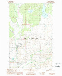
1989 Map of Nespelem
USGS Topo · Published 1989About this map
The Colville Indian Reservation encompasses this high-plateau landscape, centered on the confluence of the Nespelem River and the Little Nespelem River. The settlement of Nespelem serves as a primary hub, with the nearby Colville Indian Agency and an Airport indicating the administrative and logistical importance of this location during the late 1980s. Water management and resource extraction are evident through features like the Gaging Sta along the river and scattered Gravel Pit locations.
Find a feature on this map
25 named features on this map. Tap any name to fly to it.
Don’t see what you’re looking for? This feature index may not catch every label — zoom into the map to look around manually.
Map Details
Editions of this 1989 Nespelem Map
2 editions found
Other maps of this area

1950 · Nespelem
USGS Topo · 1:62,500

1950 · Alameda Flat
USGS Topo · 1:62,500

1952 · Alameda Flat
USGS Topo · 1:62,500

1952 · Disautel
USGS Topo · 1:62,500

1953 · Bald Knob
USGS Topo · 1:62,500

1954 · Okanogan
USGS Topo · 1:250,000

1958 · Okanogan
USGS Topo · 1:250,000
1983 · Omak
USGS Topo · 1:100,000

1984 · Nespelem
USGS Topo · 1:100,000

1986 · Central Peak
USGS Topo · 1:24,000