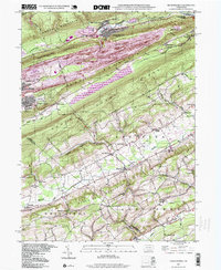
1997 Map of Nesquehoning
USGS Topo · Published 1999About this map
Nesquehoning and Lansford sit at the northern edge of this Pennsylvania landscape, where a series of steep, parallel ridges dominate the geography. Between Pisgah Mountain and Mauch Chunk Ridge, the waters of Mauch Chunk Lake fill the valley, while the Lehigh River cuts through the northeast corner at Jim Thorpe. This 1990s update, based on mid-century topography, reveals the enduring industrial and social footprint of the coal region.
Find a feature on this map
51 named features on this map. Tap any name to fly to it.
Don’t see what you’re looking for? This feature index may not catch every label — zoom into the map to look around manually.
Map Details
Editions of this 1997 Nesquehoning Map
This is the sole edition of this map. No revisions or reprints were ever made.
Other maps of this area

1889 · Hazleton
USGS Topo · 1:62,500

1891 · Hazleton
USGS Topo · 1:62,500

1893 · Hazleton
USGS Topo · 1:62,500

1902 · Slatington
USGS Topo · 1:62,500

1909 · Hamburg
USGS Topo · 1:62,500

1911 · Hamburg
USGS Topo · 1:62,500

1922 · Mauch Chunk
USGS Topo · 1:62,500

1924 · Mauch Chunk
USGS Topo · 1:62,500

1937 · Allentown West
USGS Topo · 1:48,000

1942 · Allentown West
USGS Topo · 1:62,500