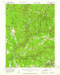
1948 Map of Nevada City
USGS Topo · Published 1961About this map
Nevada City sits at the heart of this post-war landscape, where the legacies of the California gold rush meet mid-century forest management and water reclamation efforts. The northern reaches are dominated by the Plumas National Forest and Tahoe National Forest, while the river valleys show a complex network of mining history and ranching. Significant water features like the Bullards Bar Reservoir on the North Fork Yuba River and Lake Francis illustrate the era's infrastructure, supporting local settlements such as North San Juan and Camptonville.
Find a feature on this map
165 named features on this map. Tap any name to fly to it.
Don’t see what you’re looking for? This feature index may not catch every label — zoom into the map to look around manually.
Map Details
Editions of this 1948 Nevada City Map
4 editions found

Other maps of this area

1888 · Smartsville
USGS Topo · 1:125,000

1888 · Bidwell Bar
USGS Topo · 1:125,000

1891 · Bidwell Bar
USGS Topo · 1:125,000

1891 · Downieville
USGS Topo · 1:125,000

1891 · Colfax
USGS Topo · 1:125,000

1891 · Smartsville
USGS Topo · 1:125,000

1892 · Smartsville
USGS Topo · 1:125,000

1892 · Colfax
USGS Topo · 1:125,000

1893 · Bidwell Bar
USGS Topo · 1:125,000

1893 · Downieville
USGS Topo · 1:125,000