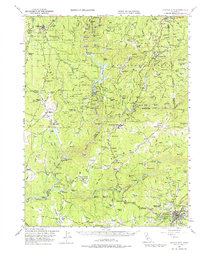
1948 Map of Nevada City
USGS Topo · Published 1976About this map
Gold mining operations and hydroelectric infrastructure define this 1940s landscape where Yuba River forks converge. The terrain is marked by numerous historic lode and placer claims, including the Mother Lode Mine, Indiana Mine, and the Champion Mine near the southern edge of the quadrangle. Significant water management for power and mining is evident at the Bullards Bar Reservoir and the Colgate Powerhouse, while the Nevada City Rancheria provides a critical record of Indigenous presence in the region.
Find a feature on this map
117 named features on this map. Tap any name to fly to it.
Don’t see what you’re looking for? This feature index may not catch every label — zoom into the map to look around manually.
Map Details
Editions of this 1948 Nevada City Map
4 editions found

Other maps of this area

1888 · Smartsville
USGS Topo · 1:125,000

1888 · Bidwell Bar
USGS Topo · 1:125,000

1891 · Bidwell Bar
USGS Topo · 1:125,000

1891 · Downieville
USGS Topo · 1:125,000

1891 · Colfax
USGS Topo · 1:125,000

1891 · Smartsville
USGS Topo · 1:125,000

1892 · Smartsville
USGS Topo · 1:125,000

1892 · Colfax
USGS Topo · 1:125,000

1893 · Bidwell Bar
USGS Topo · 1:125,000

1893 · Downieville
USGS Topo · 1:125,000