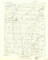
1894 Map of Nevada
USGS Topo · Published 1950About this map
The rail-and-river network of southwest Missouri dominates this late 19th-century landscape, centered on the growing junction at Nevada. This survey, conducted before the wide adoption of spirit level control, documents the region's development as the Missouri Pacific Railroad Lexington and Southern Division and the Missouri Kansas and Texas Railroad intersected, fueling local economies in Vernon and Barton counties. The terrain transitions from the Little Osage River in the north to the Muddy Fork of Spring River in the south, punctuated by landmarks like Blue Mound. Small agricultural and trade outposts such as Moundville, Montevallo, and El Dorado Springs are clearly identified, many positioned along the emerging rail lines. This map serves as an essential record of the county seats and rural townships before 20th-century road systems redefined the prairie transit patterns.
Find a feature on this map
69 named features on this map. Tap any name to fly to it.
Don’t see what you’re looking for? This feature index may not catch every label — zoom into the map to look around manually.
Map Details
Editions of this 1894 Nevada Map
5 editions found

Other maps of this area

1884 · Fort Scott
USGS Topo · 1:125,000

1886 · Nevada
USGS Topo · 1:125,000

1886 · Joplin
USGS Topo · 1:125,000

1886 · Stockton
USGS Topo · 1:125,000

1886 · Greenfield
USGS Topo · 1:125,000

1886 · Fort Scott
USGS Topo · 1:125,000

1886 · Carthage
USGS Topo · 1:125,000

1887 · Clinton
USGS Topo · 1:125,000

1887 · Butler
USGS Topo · 1:125,000

1887 · Mound City
USGS Topo · 1:125,000