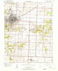
1933 Map of Nevada
USGS Topo · Published 1972About this map
Nevada serves as the focal point of this 1933 survey, appearing as a significant rail and institutional hub in Vernon County. The city is defined by its connections to the Missouri Pacific and Kansas Missouri Texas railroads, which facilitated the growth of local industry and large-scale landmarks like the Insane Asylum and St Francis Convent. Beyond the city grid, the landscape is dotted with rural education and spiritual centers, including Board Sch and Marvin Chapel, reflecting a deeply settled agricultural community.
Find a feature on this map
41 named features on this map. Tap any name to fly to it.
Don’t see what you’re looking for? This feature index may not catch every label — zoom into the map to look around manually.
Map Details
Editions of this 1933 Nevada Map
3 editions found
Other maps of this area

1886 · Nevada
USGS Topo · 1:125,000

1894 · Nevada
USGS Topo · 1:125,000

1933 · Camp Clark
USGS Topo · 1:24,000

1938 · Metz
USGS Topo · 1:24,000

1938 · Horton
USGS Topo · 1:24,000

1939 · Metz
USGS Topo · 1:24,000

1939 · Horton
USGS Topo · 1:24,000

1939 · Dederick
USGS Topo · 1:24,000
1939 · Harwood
USGS Topo · 1:24,000

1939 · Moundville
USGS Topo · 1:24,000