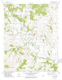
1975 Map of New Albany
USGS Topo · Published 1978About this map
The settlement of New Albany sits at a critical junction of the Fall River and the St Louis-San Francisco railroad, serving as a hub for the surrounding prairies of Wilson, Elk, and Greenwood Counties. This mid-1970s landscape reveals a region defined by its water resources and emerging energy extraction, with numerous Oil Wells peppered across the river bends. The topography is marked by named ranges and springs, including Salt Springs to the northwest and the Painterhood region in the south.
Find a feature on this map
24 named features on this map. Tap any name to fly to it.
Don’t see what you’re looking for? This feature index may not catch every label — zoom into the map to look around manually.
Map Details
Editions of this 1975 New Albany Map
This is the sole edition of this map. No revisions or reprints were ever made.
Other maps of this area

1885 · Eureka
USGS Topo · 1:125,000

1885 · Sedan
USGS Topo · 1:125,000

1886 · Fredonia
USGS Topo · 1:125,000

1886 · Independence
USGS Topo · 1:125,000

1888 · Eureka
USGS Topo · 1:125,000

1889 · Sedan
USGS Topo · 1:125,000

1894 · Fredonia
USGS Topo · 1:125,000

1894 · Independence
USGS Topo · 1:125,000

1894 · Eureka
USGS Topo · 1:125,000

1905 · Independence
USGS Topo · 1:125,000