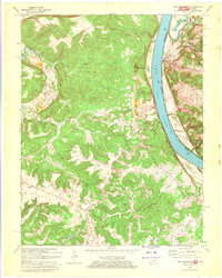
1970 Map of New Amsterdam
USGS Topo · Published 1972About this map
New Amsterdam sits prominently along a wide bend in the Ohio River, serving as a focal point for the borderlands between Indiana and Kentucky. By the early 1970s, this riverine corridor maintained a landscape of steep ridges and deep hollows, notably around Chism Ridge and the Turkey Heaven Ridge. The map documents the persistent rural character of Harrison County and Meade County, where small settlements like Battletown and Andyville anchor the surrounding uplands. Local history is recorded in sites like Greer Cem and various upland springs, including Blue Spring and Mud Springs. The topographical detail highlights the significance of water resources, from the narrow Wolf Creek to the Overflow Pond, illustrating how the drainage of the Lapland area and Dry Fork shaped the placement of early roads and homesites.
Find a feature on this map
28 named features on this map. Tap any name to fly to it.
Don’t see what you’re looking for? This feature index may not catch every label — zoom into the map to look around manually.
Map Details
Editions of this 1970 New Amsterdam Map
2 editions found
Other maps of this area

1928 · Hardinsburg
USGS Topo · 1:48,000

1931 · Hardinsburg
USGS Topo · 1:62,500

1931 · Corydon
USGS Topo · 1:62,500

1941 · Ekron
USGS Topo · 1:62,500

1944 · Corydon West
USGS Topo · 1:24,000

1946 · Leavenworth
USGS Topo · 1:24,000

1947 · Irvington
USGS Topo · 1:24,000

1947 · Lodiburg
USGS Topo · 1:24,000

1947 · Leavenworth
USGS Topo · 1:24,000

1947 · Corydon West
USGS Topo · 1:24,000