1912 Map of New Athens
USGS Topo · Published 1948About this map
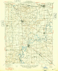
New Athens sits at the heart of this survey, established as a prominent river crossing and rail junction where the Kaskaskia River meets the Illinois Central RR. The landscape is a detailed grid of small agricultural communities and rural schoolhouses, illustrating the late-Edwardian development of St. Clair and Monroe counties. Numerous family-named schools like Engelmann School and Hertel School pepper the countryside, while the southern reach of the map shows the transition into coal-influenced areas near Marissa and Lenzburg. The presence of several sloughs and lakes, including Bottom Lake and Brush Lake, alongside the winding river path, highlights the influence of the drainage basin on early settlement patterns. Cultural details like Greenmount Cem and the St Louis and Cairo Line provide specific data points for genealogists researching the roots of these Illinois townships during the first half of the twentieth century.
Find a feature on this map
97 named features on this map. Tap any name to fly to it.
Don’t see what you’re looking for? This feature index may not catch every label — zoom into the map to look around manually.
Map Details
Editions of this 1912 New Athens Map
2 editions found
Other maps of this area

1888 · St. Louis
USGS Topo · 1:62,500

1906 · Breese
USGS Topo · 1:62,500

1907 · Breese
USGS Topo · 1:62,500

1907 · Belleville
USGS Topo · 1:62,500

1910 · Okawville
USGS Topo · 1:62,500

1910 · Waterloo
USGS Topo · 1:62,500

1912 · New Athens
USGS Topo · 1:62,500

1912 · Baldwin
USGS Topo · 1:62,500

1913 · Waterloo
USGS Topo · 1:62,500

1914 · Baldwin
USGS Topo · 1:62,500