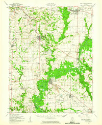
1954 Map of New Athens
USGS Topo · Published 1960About this map
The Kaskaskia River winds through the heart of this mid-century landscape, defining the character of southwestern Illinois as it flows past New Athens. This era of the river's history is preserved here before modern engineering significantly altered its natural course, showing a complex network of oxbows and backwaters like Halfmoon Lake and White Cabin Slough. To the north, the Louisville and Nashville railroad serves the established town of Mascoutah, while the Illinois Central corridor connects Freeburg and Lenzburg through a countryside dotted with rural schoolhouses like Five Points Sch and Hertel Sch.
Find a feature on this map
104 named features on this map. Tap any name to fly to it.
Don’t see what you’re looking for? This feature index may not catch every label — zoom into the map to look around manually.
Map Details
Editions of this 1954 New Athens Map
This is the sole edition of this map. No revisions or reprints were ever made.
Other maps of this area

1888 · St. Louis
USGS Topo · 1:62,500

1906 · Breese
USGS Topo · 1:62,500

1907 · Breese
USGS Topo · 1:62,500

1907 · Belleville
USGS Topo · 1:62,500

1910 · Okawville
USGS Topo · 1:62,500

1910 · Waterloo
USGS Topo · 1:62,500

1912 · New Athens
USGS Topo · 1:62,500

1912 · Baldwin
USGS Topo · 1:62,500

1913 · Waterloo
USGS Topo · 1:62,500

1914 · Baldwin
USGS Topo · 1:62,500