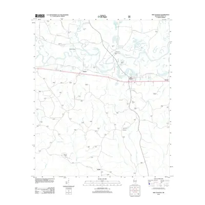
2012 Map of New Augusta
USGS Topo · Published 2012About this map
Old Augusta and the current town of New Augusta anchor this study of the Leaf River basin in Perry County. The landscape is defined by the winding course of the river and its numerous tributaries, including Tallabala Cr, Denham Cr, and Milky Cr. For genealogists, the map is remarkably dense with family-named burial sites, such as Nichols Cem, Hollimon Cem, McSwain Cem, and Stevens Cem, often located near early homestead routes like Hollimon Cemetery Rd.
Find a feature on this map
57 named features on this map. Tap any name to fly to it.
Don’t see what you’re looking for? This feature index may not catch every label — zoom into the map to look around manually.
Map Details
Editions of this 2012 New Augusta Map
This is the sole edition of this map. No revisions or reprints were ever made.
Other maps of this area

1947 · Beaumont
USGS Topo · 1:62,500

1947 · New Augusta
USGS Topo · 1:62,500

1949 · Beaumont
USGS Topo · 1:62,500

1949 · New Augusta
USGS Topo · 1:62,500

1953 · Hattiesburg
USGS Topo · 1:250,000

1958 · Hattiesburg
USGS Topo · 1:250,000

1964 · Carterville
USGS Topo · 1:24,000

1964 · Ovett SE
USGS Topo · 1:24,000

1964 · Richton
USGS Topo · 1:24,000
1982 · Beaumont
USGS Topo · 1:24,000