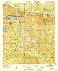
1949 Map of New Augusta
USGS Topo · Published 1949About this map
The Leaf River and Black Creek basins define this portion of South Mississippi, where the transition between the river-focused settlement of Old Augusta and the railroad-oriented New Augusta is clearly visible. The landscape is dominated by the Camp Shelby Military Reservation and the De Soto National Forest, reflecting a mid-century period of federal land management and military readiness. This 1949 edition captures a diverse local infrastructure, from the U S Forest Service Ashe Nursery to the McLaurin Landing Field. Family history is preserved through scattered rural sites like Granny Bounds Cem and several country schools, including the Forrest County Agricultural Sch and Whites Sch. The transport network shows a heavy reliance on the Southern Railway and Illinois Central, which served timber and agricultural interests across Forrest and Perry counties.
Find a feature on this map
71 named features on this map. Tap any name to fly to it.
Don’t see what you’re looking for? This feature index may not catch every label — zoom into the map to look around manually.
Map Details
Editions of this 1949 New Augusta Map
2 editions found
Other maps of this area

1947 · Beaumont
USGS Topo · 1:62,500

1947 · Wiggins
USGS Topo · 1:62,500

1947 · New Augusta
USGS Topo · 1:62,500

1947 · Benndale
USGS Topo · 1:62,500

1949 · Wiggins
USGS Topo · 1:62,500

1949 · Beaumont
USGS Topo · 1:62,500

1949 · New Augusta
USGS Topo · 1:62,500

1949 · Benndale
USGS Topo · 1:62,500

1953 · Hattiesburg
USGS Topo · 1:250,000

1953 · Mobile
USGS Topo · 1:250,000