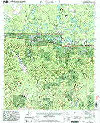
2000 Map of New Augusta
USGS Topo · Published 2003About this map
The Leaf River snakes through the center of this terrain, marking the geographic divide between the older riverfront site of Old Augusta and the modern town of New Augusta. This region in Perry County reflects a shift in settlement patterns, with the older site characterized by several family burial grounds like the Stevens Cem and McSwain Cem, while the newer town hosts the Perry County Sch. To the south, the landscape transitions into the protected wilderness of the De Soto National Forest, which is crisscrossed by a network of drainage ways such as Milky Creek and Sweetwater Branch. The industrial and strategic footprint of the era is evident in the Illinois Central Railroad corridor and expansive military zones, including a Dedicated Impact Area and the Davis KD Range, highlighting the dual role of the land for timber production and military training.
Find a feature on this map
44 named features on this map. Tap any name to fly to it.
Don’t see what you’re looking for? This feature index may not catch every label — zoom into the map to look around manually.
Map Details
Editions of this 2000 New Augusta Map
This is the sole edition of this map. No revisions or reprints were ever made.
Other maps of this area

1947 · Beaumont
USGS Topo · 1:62,500

1947 · New Augusta
USGS Topo · 1:62,500

1949 · Beaumont
USGS Topo · 1:62,500

1949 · New Augusta
USGS Topo · 1:62,500

1953 · Hattiesburg
USGS Topo · 1:250,000

1958 · Hattiesburg
USGS Topo · 1:250,000

1964 · Carterville
USGS Topo · 1:24,000

1964 · Ovett SE
USGS Topo · 1:24,000

1964 · Richton
USGS Topo · 1:24,000
1982 · Beaumont
USGS Topo · 1:24,000