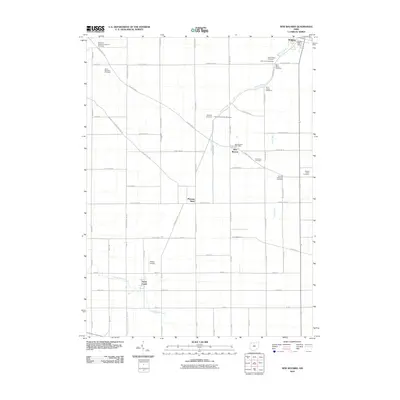
2010 Map of New Bavaria
USGS Topo · Published 2010About this map
New Bavaria and Pleasant Bend are focal points of this rural landscape in Henry County, where the topography is defined by the gentle drainage of School Creek and Lost Creek toward the north. A dense concentration of early faith-based sites characterizes the area, particularly along the diagonal corridor of New Bavaria Rd. Numerous burial grounds, including the Old Saint Stephens Lutheran Cemetery, Saint Marys Cemetery, and the German Reformed Cemetery, suggest a deeply rooted settlement pattern of German immigrant communities and established family parishes. Further south, the terrain levels as it approaches North Powell Creek and South Powell Creek, where the Hiltner Airport sits amidst a strictly partitioned grid of county roads. The northern edge is anchored by Holgate, where the Holgate Post Office serves as a key landmark in this agrarian township.
Find a feature on this map
45 named features on this map. Tap any name to fly to it.
Don’t see what you’re looking for? This feature index may not catch every label — zoom into the map to look around manually.
Map Details
Editions of this 2010 New Bavaria Map
This is the sole edition of this map. No revisions or reprints were ever made.
Other maps of this area

1907 · Defiance
USGS Topo · 1:62,500

1908 · Ottawa
USGS Topo · 1:62,500

1908 · Napoleon
USGS Topo · 1:62,500

1909 · Defiance
USGS Topo · 1:62,500

1909 · Continental
USGS Topo · 1:62,500

1953 · Fort Wayne
USGS Topo · 1:250,000

1956 · Fort Wayne
USGS Topo · 1:250,000

1959 · Defiance East
USGS Topo · 1:24,000

1959 · Florida
USGS Topo · 1:24,000

1960 · Ottawa
USGS Topo · 1:24,000