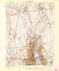
1941 Map of New Bedford North
USGS Topo · Published 1941About this map
New Bedford Harbor and the Acushnet River serve as the central axis for this coastal Massachusetts landscape, separating the dense urban grid of New Bedford from the established settlements of Fairhaven and Acushnet. The 1941 edition reflects a mature maritime and industrial economy, featuring the New York New Haven and Hartford RR and waterfront infrastructure like the State Pier. Beyond the urban core, the map reveals a diverse inland character, from the Evergreen Racetrack in Plainville to the numerous burial grounds such as St Marys Cem and Riverside Cem. Large wetland areas like Bolton Cedar Swamp and Hocomock Swamp dominate the northern terrain, indicating a landscape where industrial development was carefully constrained by natural topography and water resources like the New Bedford Reservoir. Local institutions, including Sassaquin Hospital and the Fairhaven High Sch, are clearly marked for genealogical and historical research.
Find a feature on this map
96 named features on this map. Tap any name to fly to it.
Don’t see what you’re looking for? This feature index may not catch every label — zoom into the map to look around manually.
Map Details
Editions of this 1941 New Bedford North Map
3 editions found

Other maps of this area

1885 · New Bedford
USGS Topo · 1:62,500

1885 · Middleboro
USGS Topo · 1:62,500

1885 · Taunton
USGS Topo · 1:62,500

1888 · New Bedford
USGS Topo · 1:62,500

1888 · Fall River
USGS Topo · 1:62,500

1888 · Taunton
USGS Topo · 1:62,500

1888 · Middleboro
USGS Topo · 1:62,500

1893 · Taunton
USGS Topo · 1:62,500

1893 · Middleboro
USGS Topo · 1:62,500

1893 · Fall River
USGS Topo · 1:62,500