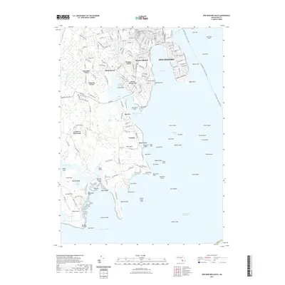
2021 Map of New Bedford South
USGS Topo · Published 2021About this map
Bliss Corner and South Dartmouth form the heart of this coastal study, where the residential grids of New Bedford meet the irregular shoreline of Clarks Cove. The landscape is defined by its maritime orientation, featuring the path of the New Bedford - Oak Bluffs Ferry cutting across Buzzards Bay. Inland, the map documents numerous small communities such as Apponagansett, Nonquitt, and Shore Acres, alongside specialized land use markers like Cranberry Bog Corner. Genealogists may find interest in the documented locations of Saint Johns Cem, Rural Cem, and Hill Meadow Cem. This contemporary perspective captures the modern development of these historic Massachusetts towns while clearly marking landmarks like the Plummer Memorial Bridge and coastal features such as Rickettsons Point and the marshes surrounding the Little River.
Find a feature on this map
74 named features on this map. Tap any name to fly to it.
Don’t see what you’re looking for? This feature index may not catch every label — zoom into the map to look around manually.
Map Details
Editions of this 2021 New Bedford South Map
This is the sole edition of this map. No revisions or reprints were ever made.
Other maps of this area

1885 · New Bedford
USGS Topo · 1:62,500

1885 · Sakonnet
USGS Topo · 1:62,500

1887 · Gay Head
USGS Topo · 1:62,500

1888 · New Bedford
USGS Topo · 1:62,500

1888 · Fall River
USGS Topo · 1:62,500

1888 · Sakonnet
USGS Topo · 1:62,500

1889 · Gay Head
USGS Topo · 1:62,500

1893 · Gay Head
USGS Topo · 1:62,500

1893 · Sakonnet
USGS Topo · 1:62,500

1893 · Fall River
USGS Topo · 1:62,500