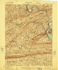
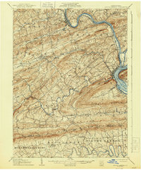
1907 Map of New Bloomfield
USGS Topo · Published 1921About this map
The Juniata River carves a dramatic winding path through the ridges of Perry County, meeting the Susquehanna River at a critical junction of transport and industry. In the early 20th century, this landscape was defined by its water-and-rail infrastructure, featuring a prominent Aqueduct near the confluence and the heavy traffic of the Pennsylvania Railroad. The county seat at New Bloomfield PO serves as a central hub, surrounded by smaller agrarian and industrial outposts like Juniata Furnace and Milford. The terrain is strictly governed by long, parallel ridges such as Cove Mountain and Blue Mountain, which forced travelers and commerce through narrow crossings like Sterrett Gap and Clarks Ferry. This map reveals the intricate network of family-named settlements and rural post offices that once peppered the valleys before modern highway expansion bypassed many of these local centers.
Find a feature on this map
81 named features on this map. Tap any name to fly to it.
Don’t see what you’re looking for? This feature index may not catch every label — zoom into the map to look around manually.
Map Details
Editions of this 1907 New Bloomfield Map
6 editions found
Other maps of this area

1892 · Harrisburg
USGS Topo · 1:62,500

1893 · Millersburg
USGS Topo · 1:62,500

1899 · Harrisburg
USGS Topo · 1:62,500

1904 · Carlisle
USGS Topo · 1:62,500

1906 · New Cumberland
USGS Topo · 1:62,500

1907 · New Bloomfield
USGS Topo · 1:62,500

1907 · Millerstown
USGS Topo · 1:62,500

1919 · Newville
USGS Topo · 1:62,500

1924 · Harrisburg
USGS Topo · 1:62,500

1925 · Mifflintown
USGS Topo · 1:48,000