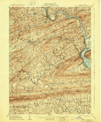
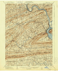
1907 Map of New Bloomfield
USGS Topo · Published 1929About this map
Bloomfield serves as a central hub in this early 20th-century landscape, where the ridge-and-valley topography of Perry County dictated the paths of commerce and travel. The Pennsylvania RR and the Newport & Shermans Valley RR skirt the edges of prominent landforms like Mahanoy Ridge and Buffalo Ridge, following the level banks of the Juniata River and Sherman Creek. The map documents a period when local industry and natural resources were deeply intertwined, evidenced by labels for the Juniata Furnace and Kings Mill.
Find a feature on this map
86 named features on this map. Tap any name to fly to it.
Don’t see what you’re looking for? This feature index may not catch every label — zoom into the map to look around manually.
Map Details
Editions of this 1907 New Bloomfield Map
6 editions found
Other maps of this area

1892 · Harrisburg
USGS Topo · 1:62,500

1893 · Millersburg
USGS Topo · 1:62,500

1899 · Harrisburg
USGS Topo · 1:62,500

1904 · Carlisle
USGS Topo · 1:62,500

1906 · New Cumberland
USGS Topo · 1:62,500

1907 · New Bloomfield
USGS Topo · 1:62,500

1907 · Millerstown
USGS Topo · 1:62,500

1919 · Newville
USGS Topo · 1:62,500

1924 · Harrisburg
USGS Topo · 1:62,500

1925 · Mifflintown
USGS Topo · 1:48,000