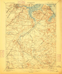
1901 Map of New Brunswick
USGS Topo · Published 1909About this map
New Brunswick and the surrounding townships of Middlesex and Monmouth counties are defined by a complex network of waterways and early rail lines at the turn of the century. The Raritan River and Raritan Bay serve as the primary geographical anchors, while the Pennsylvania Railroad and its various divisions, including the Pennsylvania R.R. (Amboy Division), facilitate movement through Sayreville and South Brunswick. Notable landmarks such as the Monmouth Battle Ground and the State Reform School near Jamesburg provide significant historical touchpoints.
Find a feature on this map
99 named features on this map. Tap any name to fly to it.
Don’t see what you’re looking for? This feature index may not catch every label — zoom into the map to look around manually.
Map Details
Editions of this 1901 New Brunswick Map
5 editions found

Other maps of this area

1888 · Plainfield
USGS Topo · 1:62,500

1888 · Bordentown
USGS Topo · 1:62,500

1888 · New Brunswick
USGS Topo · 1:62,500

1888 · Princeton
USGS Topo · 1:62,500

1888 · Asbury Park
USGS Topo · 1:62,500

1888 · Cassville
USGS Topo · 1:62,500

1888 · Sandy Hook
USGS Topo · 1:62,500

1891 · Somerville
USGS Topo · 1:62,500

1893 · Bordentown
USGS Topo · 1:62,500

1893 · New Brunswick
USGS Topo · 1:62,500