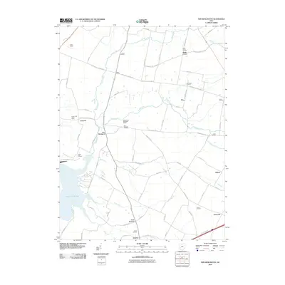
2010 Map of New Burlington
USGS Topo · Published 2010About this map
Caesar Creek Lake dominates the southwestern corner of this survey, marking a significant hydrological shift from the natural flow of Caesar Creek and its many tributaries. The area is defined by a dense network of early crossroads and small settlements like New Burlington, Cornstalk, and Gurneyville. A remarkably high concentration of small burial grounds, including the Zoar Church Cemetery, Chester Cemetery, and Sharon Cemetery, points to the deep generational roots of the farming families who established these townships. The local infrastructure is highlighted by features such as the West Engle Mill Road Bridge over Anderson Fork, while the northern reaches maintain a rural character around Maple Corner and the small Fricke Airport.
Find a feature on this map
66 named features on this map. Tap any name to fly to it.
Don’t see what you’re looking for? This feature index may not catch every label — zoom into the map to look around manually.
Map Details
Editions of this 2010 New Burlington Map
This is the sole edition of this map. No revisions or reprints were ever made.
Other maps of this area

1907 · Blanchester
USGS Topo · 1:62,500

1913 · Waynesville
USGS Topo · 1:62,500

1914 · Morrow
USGS Topo · 1:62,500

1915 · Waynesville
USGS Topo · 1:62,500

1916 · Morrow
USGS Topo · 1:62,500

1917 · Xenia
USGS Topo · 1:62,500

1947 · Columbus
USGS Topo · 1:250,000

1953 · Cincinnati
USGS Topo · 1:250,000

1955 · New Burlington
USGS Topo · 1:24,000
1955 · Waynesville
USGS Topo · 1:24,000