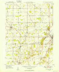
1949 Map of New Castle West
USGS Topo · Published 1949About this map
The Big Blue River valley and its surrounding townships define this 1949 survey of western Henry County. The landscape is a patchwork of rural agriculture and early-century industrial infrastructure, anchored by the western edge of New Castle and smaller hubs like Cadiz and Greensboro. Genealogists will find a wealth of specific local landmarks, including the South Mound Cemetery, Quaker Cem, and the Sugar Grove Sch. Transportation is a primary theme here, with the Pennsylvania and New York Chicago And ST Louis railroads cutting through the terrain alongside the New York Central line. The transition from farm to town is further evidenced by institutional markers like the County Home and the presence of the Western Air Field and Memorial Park, providing a clear look at Indiana’s mid-century rural development and communal organization before modern suburban expansion.
Find a feature on this map
35 named features on this map. Tap any name to fly to it.
Don’t see what you’re looking for? This feature index may not catch every label — zoom into the map to look around manually.
Map Details
Editions of this 1949 New Castle West Map
2 editions found
Other maps of this area

1948 · Lewisville
USGS Topo · 1:24,000

1949 · New Castle West
USGS Topo · 1:24,000

1950 · New Castle East
USGS Topo · 1:24,000

1950 · Dunreith
USGS Topo · 1:24,000

1950 · Lewisville
USGS Topo · 1:24,000

1953 · Cincinnati
USGS Topo · 1:250,000

1953 · Muncie
USGS Topo · 1:250,000

1956 · Muncie
USGS Topo · 1:250,000

1957 · Cincinnati
USGS Topo · 1:250,000

1960 · New Castle West
USGS Topo · 1:24,000