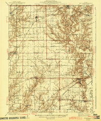
1944 Map of New Douglas
USGS Topo · Published 1944About this map
Shoal Creek and its companion, Little Shoal Creek, carve a winding path through this corner of Madison and Bond counties, defining a landscape of agricultural plateaus and timbered breaks. At the time of this mid-century survey, the rural economy was anchored by a dense network of one-room schoolhouses such as Hedgebound Sch, Kauffman Sch, and Wider Range Sch. The railroad lines of the New York Chicago and St Louis and the Pennsylvania intersect the territory, connecting established settlements like New Douglas, Sorento, and Pocahontas to wider markets.
Find a feature on this map
72 named features on this map. Tap any name to fly to it.
Don’t see what you’re looking for? This feature index may not catch every label — zoom into the map to look around manually.
Map Details
Editions of this 1944 New Douglas Map
2 editions found

Other maps of this area

1906 · Breese
USGS Topo · 1:62,500

1907 · Breese
USGS Topo · 1:62,500

1907 · Belleville
USGS Topo · 1:62,500

1910 · Carlyle
USGS Topo · 1:62,500

1912 · Gillespie
USGS Topo · 1:62,500

1915 · Gillespie
USGS Topo · 1:62,500

1915 · Mount Olive
USGS Topo · 1:62,500

1927 · Edwardsville
USGS Topo · 1:62,500

1932 · Edwardsville
USGS Topo · 1:62,500

1932 · Greenville
USGS Topo · 1:62,500