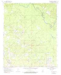
1970 Map of New Edinburg
USGS Topo · Published 1990About this map
New Edinburg serves as the focal point of this Cleveland County landscape, where the meandering Saline River defines the northeastern boundary. The terrain is a network of small watercourses, including Cottonmouth Creek and Frazier Creek, which cut through a region dominated by timber and small rural clearings. This 1970 snapshot of the area reflects a deeply rooted community structure, evidenced by the numerous small rural churches and family-named landmarks scattered across the townships of Kings Land and Redland.
Find a feature on this map
24 named features on this map. Tap any name to fly to it.
Don’t see what you’re looking for? This feature index may not catch every label — zoom into the map to look around manually.
Map Details
Editions of this 1970 New Edinburg Map
2 editions found
Other maps of this area

1953 · El Dorado
USGS Topo · 1:250,000

1957 · El Dorado
USGS Topo · 1:250,000

1958 · El Dorado
USGS Topo · 1:250,000

1960 · El Dorado
USGS Topo · 1:250,000

1966 · Kingsland
USGS Topo · 1:24,000
1970 · Fordyce NE
USGS Topo · 1:24,000
1970 · Calmer
USGS Topo · 1:24,000

1970 · New Edinburg
USGS Topo · 1:24,000

1970 · Herbine
USGS Topo · 1:24,000
1970 · Rison
USGS Topo · 1:24,000