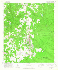
1965 Map of New Ellenton
USGS Topo · Published 1967About this map
New Ellenton stands as the primary residential hub in this mid-1960s survey of Aiken County, developed in the shadow of the US Reservation Savannah River Plant. The landscape is a transition between suburban growth and industrial-scale land management, evidenced by the numerous claypits and sandpits that pockmark the terrain alongside extensive firebreaks and jeep trails. Local community life is anchored by a dense network of country churches and educational centers, including Talatha-Hawthorne Sch and Greendale Sch. The mapping of the US Reservation Boundary across the southern half of the sheet underscores the area's Cold War-era significance, where former settlements like Talatha and Johnson Crossroads sit at the edge of the Atomic Energy Commission's vast restricted territory. Hydrological features like Anderson Millpond and Chapman Pond provide a contrast to the geometric patterns of the plant's managed forests.
Find a feature on this map
38 named features on this map. Tap any name to fly to it.
Don’t see what you’re looking for? This feature index may not catch every label — zoom into the map to look around manually.
Map Details
Editions of this 1965 New Ellenton Map
3 editions found
Other maps of this area

1920 · Aiken
USGS Topo · 1:48,000

1920 · Talatha
USGS Topo · 1:48,000

1921 · Augusta
USGS Topo · 1:62,500

1921 · Aiken
USGS Topo · 1:62,500

1921 · Talatha
USGS Topo · 1:62,500

1923 · Warrenville
USGS Topo · 1:48,000

1928 · Warrenville
USGS Topo · 1:62,500

1943 · Aiken
USGS Topo · 1:62,500

1943 · Augusta East
USGS Topo · 1:125,000

1943 · Warrenville
USGS Topo · 1:62,500