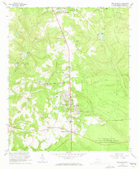
1965 Map of New Ellenton
USGS Topo · Published 1973About this map
New Ellenton sits at the heart of this landscape, reflecting the mid-century growth and reorganization of this portion of Aiken County. The map captures the area during its tenure as a neighbor to the US Reservation Savannah River Plant, with the US Reservation Boundary cutting across the southern terrain. This intersection of local life and federal industry is marked by numerous residential developments like College Acres and vital community hubs such as Johnson Crossroads.
Find a feature on this map
48 named features on this map. Tap any name to fly to it.
Don’t see what you’re looking for? This feature index may not catch every label — zoom into the map to look around manually.
Map Details
Editions of this 1965 New Ellenton Map
3 editions found
Other maps of this area

1920 · Aiken
USGS Topo · 1:48,000

1920 · Talatha
USGS Topo · 1:48,000

1921 · Augusta
USGS Topo · 1:62,500

1921 · Aiken
USGS Topo · 1:62,500

1921 · Talatha
USGS Topo · 1:62,500

1923 · Warrenville
USGS Topo · 1:48,000

1928 · Warrenville
USGS Topo · 1:62,500

1943 · Aiken
USGS Topo · 1:62,500

1943 · Augusta East
USGS Topo · 1:125,000

1943 · Warrenville
USGS Topo · 1:62,500