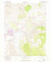
1968 Map of New Empire
USGS Topo · Published 1976About this map
The industrial and institutional landscape of eastern Carson City is captured here during a period of urban expansion in the late 1960s and early 1970s. The Carson River winds through the center of the sheet, its banks lined with the remnants of the Comstock era's processing infrastructure, including the Eureka Mill (Ruins), Morgan Mill (Ruins), and the Old Mexican Mill. These ruins signify the transition from a nineteenth-century milling economy to a more modern municipal layout.
Find a feature on this map
51 named features on this map. Tap any name to fly to it.
Don’t see what you’re looking for? This feature index may not catch every label — zoom into the map to look around manually.
Map Details
Editions of this 1968 New Empire Map
Other maps of this area

1891 · Carson
USGS Topo · 1:125,000

1893 · Carson
USGS Topo · 1:125,000

1950 · Virginia City
USGS Topo · 1:62,500

1950 · Mt. Rose
USGS Topo · 1:62,500

1952 · Mt. Rose
USGS Topo · 1:62,500

1952 · Virginia City
USGS Topo · 1:62,500

1956 · Dayton
USGS Topo · 1:62,500

1956 · Carson City
USGS Topo · 1:62,500

1957 · Reno
USGS Topo · 1:250,000

1959 · Reno
USGS Topo · 1:250,000