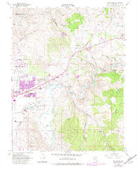
1968 Map of New Empire
USGS Topo · Published 1983About this map
Carson River mills and the industrial heritage of the Virginia Range define this landscape on the eastern outskirts of the state capital. The map records a concentration of former silver processing sites along the river, including the Old Mexican Mill and several ruins such as the Eureka Mill and Brunswick Mill. These sites represent the critical infrastructure that supported the regional mining economy, situated between the high peaks and the river's edge.
Find a feature on this map
42 named features on this map. Tap any name to fly to it.
Don’t see what you’re looking for? This feature index may not catch every label — zoom into the map to look around manually.
Map Details
Editions of this 1968 New Empire Map
Other maps of this area

1891 · Carson
USGS Topo · 1:125,000

1893 · Carson
USGS Topo · 1:125,000

1950 · Virginia City
USGS Topo · 1:62,500

1950 · Mt. Rose
USGS Topo · 1:62,500

1952 · Mt. Rose
USGS Topo · 1:62,500

1952 · Virginia City
USGS Topo · 1:62,500

1956 · Dayton
USGS Topo · 1:62,500

1956 · Carson City
USGS Topo · 1:62,500

1957 · Reno
USGS Topo · 1:250,000

1959 · Reno
USGS Topo · 1:250,000