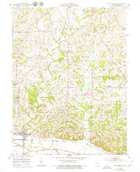
1952 Map of New Franklin
USGS Topo · Published 1979About this map
New Franklin serves as a primary hub for this portion of Howard County, where the Missouri Kansas And Texas railroad lines converge. The settlement pattern reflects a mid-century rural economy defined by township divisions including Richmond, Franklin, and Moniteau. A dense network of local schools once supported these farming communities, such as Spanish Needles Sch, Mt Zion Sch, and Cherry Grove Sch, many of which were becoming historical markers by the time of the 1970s revisions.
Find a feature on this map
32 named features on this map. Tap any name to fly to it.
Don’t see what you’re looking for? This feature index may not catch every label — zoom into the map to look around manually.
Map Details
Editions of this 1952 New Franklin Map
2 editions found
Other maps of this area

1888 · Boonville
USGS Topo · 1:125,000

1890 · Glasgow
USGS Topo · 1:125,000

1947 · Glasgow
USGS Topo · 1:62,500

1947 · Jefferson City
USGS Topo · 1:250,000

1952 · Rocheport
USGS Topo · 1:24,000

1952 · Boonville
USGS Topo · 1:24,000

1952 · New Franklin
USGS Topo · 1:24,000

1952 · Hilldale
USGS Topo · 1:24,000

1953 · Moberly
USGS Topo · 1:250,000

1953 · Fayette
USGS Topo · 1:24,000