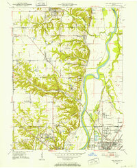
1950 Map of New Goshen
USGS Topo · Published 1960About this map
Industrial extraction and academic life define the landscape of the Washbash River valley at mid-century. Coal mining is prominent throughout, with numerous strip mines and mine dumps scarring the terrain around Shepardsville and Universal. The southern portion of the quadrangle is dominated by the sprawling campus of St Mary-of-the-Woods College and its associated churches and school facilities. Transportation history is visible through the Erie Canal (Abandoned) corridor paralleling the river, while modern rail lines like the Chicago Milwaukee St Paul and Pacific facilitate the region's heavy industry. Small settlements and pocket neighborhoods like Terre Town, Barnhart Town, and Needmore dot the rural roads, often centered around local institutions like Hayes Sch or the New Vermillion Ch.
Find a feature on this map
61 named features on this map. Tap any name to fly to it.
Don’t see what you’re looking for? This feature index may not catch every label — zoom into the map to look around manually.
Map Details
Editions of this 1950 New Goshen Map
3 editions found
Other maps of this area

1932 · Marshall
USGS Topo · 1:62,500

1937 · Marshall
USGS Topo · 1:62,500

1941 · Seelyville
USGS Topo · 1:24,000

1941 · Terre Haute
USGS Topo · 1:24,000

1942 · Dennison
USGS Topo · 1:24,000

1947 · Paris
USGS Topo · 1:62,500

1948 · Terre Haute
USGS Topo · 1:24,000

1949 · Paris
USGS Topo · 1:62,500

1950 · Rosedale
USGS Topo · 1:24,000

1950 · New Goshen
USGS Topo · 1:24,000