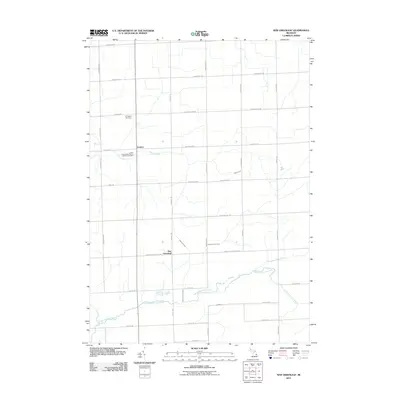
2011 Map of New Greenleaf
USGS Topo · Published 2011About this map
Ivanhoe and the rural junction of New Greenleaf anchor this portion of the Thumb region of Michigan, where a structured grid of section roads defines the agricultural landscape. The area is marked by its water systems, notably the North Branch Cass River and the South Fork Cass River which flow across the southern plains, while the Pigeon River cuts through the northern sections near the McTaggart Cemetery. This survey highlights the deep-rooted local history through its named cemeteries and community centers, such as the Saint Columbkille Roman Catholic Cemetery west of the river. The topography is relatively flat, dictated by the slow-moving waters of Greenleaf Creek and Sanilac Huron Creek, showing a landscape optimized for farming and connected by long-established transit corridors like Bay City Forestville Rd and Sebewaing Rd.
Find a feature on this map
41 named features on this map. Tap any name to fly to it.
Don’t see what you’re looking for? This feature index may not catch every label — zoom into the map to look around manually.
Map Details
Editions of this 2011 New Greenleaf Map
This is the sole edition of this map. No revisions or reprints were ever made.
Other maps of this area

1954 · Flint
USGS Topo · 1:250,000

1958 · Flint
USGS Topo · 1:250,000

1963 · New Greenleaf
USGS Topo · 1:24,000

1963 · Ubly
USGS Topo · 1:24,000

1963 · Cass City
USGS Topo · 1:24,000

1963 · Shabbona
USGS Topo · 1:24,000

1963 · Gagetown
USGS Topo · 1:24,000

1963 · Argyle
USGS Topo · 1:24,000

1970 · Bad Axe West
USGS Topo · 1:24,000
1970 · Elkton
USGS Topo · 1:24,000