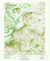
1959 Map of New Harmony
USGS Topo · Published 1963About this map
New Harmony serves as the focal point of this Indiana-Illinois border region, where the Wabash River meanders through a landscape defined by oxbows and islands. The cultural history of the Harmonist and Owenite social experiments is anchored by The Labyrinth State Mem and Murphy Park. To the north, the Mumford Hills rise above the alluvial plain, while the Illinois Central railroad connects the agricultural settlements of Griffin, Stewartsville, and Poseyville.
Find a feature on this map
104 named features on this map. Tap any name to fly to it.
Don’t see what you’re looking for? This feature index may not catch every label — zoom into the map to look around manually.
Map Details
Editions of this 1959 New Harmony Map
2 editions found
Other maps of this area

1901 · Princeton
USGS Topo · 1:62,500

1901 · Haubstadt
USGS Topo · 1:62,500

1903 · Haubstadt
USGS Topo · 1:62,500

1903 · New Harmony
USGS Topo · 1:62,500

1903 · Princeton
USGS Topo · 1:62,500

1903 · Patoka
USGS Topo · 1:125,000

1904 · Mount Carmel
USGS Topo · 1:62,500

1905 · New Haven
USGS Topo · 1:62,500

1906 · New Haven
USGS Topo · 1:62,500

1914 · Henderson
USGS Topo · 1:48,000