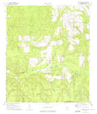
1973 Map of New Harmony
USGS Topo · Published 1976About this map
The Shoal River carves a central path through this section of Walton County, fed by a dense network of tributaries including Wolf Creek, Battle Creek, and Adams Mill Creek. In the early 1970s, the landscape was defined by its water-rich geography, featuring numerous basins and wetlands such as Teal Bay, Dios Bay, and Piney Woods Bay. This terrain is punctuated by significant local landmarks like Fox Hill and several small bodies of water including Andrews Lake and Coal Spring Lake.
Find a feature on this map
38 named features on this map. Tap any name to fly to it.
Don’t see what you’re looking for? This feature index may not catch every label — zoom into the map to look around manually.
Map Details
Editions of this 1973 New Harmony Map
2 editions found
Other maps of this area

1934 · Niceville
USGS Topo · 1:48,000

1935 · De Funiak Springs
USGS Topo · 1:48,000

1936 · Niceville
USGS Topo · 1:62,500

1938 · De Funiak Springs
USGS Topo · 1:62,500

1949 · Glendale
USGS Topo · 1:62,500

1949 · Laurel Hill
USGS Topo · 1:62,500

1950 · Laurel Hill
USGS Topo · 1:62,500

1951 · Glendale
USGS Topo · 1:62,500

1956 · Niceville
USGS Topo · 1:62,500

1957 · Pensacola
USGS Topo · 1:250,000