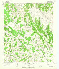
1961 Map of New Harp
USGS Topo · Published 1963About this map
New Harp sits near the headwaters of a complex drainage system where the uplands of Montague County meet northern Wise County. During the early 1960s, this landscape was defined by its winding riparian corridors, most notably Denton Creek and its various tributaries like Rush Creek and Panther Creek. The terrain is marked by small rural nodes that speak to the area's pioneer heritage, including Audubon Ch and two distinct burial grounds, Rush Cem and Cottonwood Cem. A solitary Grave label in the southwestern portion of the sheet suggests a point of specific genealogical interest, while the numerous creek branches such as Braden Branch and Cottonwood Creek illustrate the dissected nature of the North Texas prairies before modern development reshaped these drainage basins.
Find a feature on this map
12 named features on this map. Tap any name to fly to it.
Don’t see what you’re looking for? This feature index may not catch every label — zoom into the map to look around manually.
Map Details
Editions of this 1961 New Harp Map
3 editions found
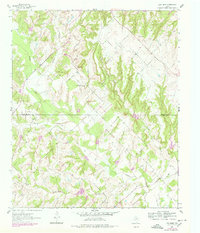
Other maps of this area

1902 · Gainesville
USGS Topo · 1:125,000

1905 · Montague
USGS Topo · 1:125,000

1943 · Gainesville
USGS Topo · 1:125,000

1954 · Sherman
USGS Topo · 1:250,000

1958 · Sherman
USGS Topo · 1:250,000

1961 · Pecan Creek
USGS Topo · 1:24,000

1961 · Salona
USGS Topo · 1:24,000

1961 · Alvord
USGS Topo · 1:24,000

1961 · Freemound
USGS Topo · 1:24,000

1961 · New Harp
USGS Topo · 1:24,000