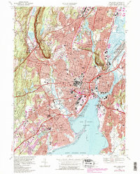
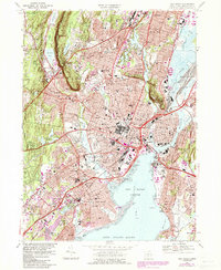
1967 Map of New Haven
USGS Topo · Published 1985About this map
The dense urban and academic core of New Haven is captured during a period of significant mid-century expansion, evidenced by the purple-tinted urban extensions around Yale University and several regional colleges. This 1967 survey, revised in the early 1980s, illustrates the complex infrastructure of the harbor area, where the Quinnipiac River meets Long Island Sound near City Point and Forbes Bluff. The landscape is dominated by institutional landmarks, from the sprawling VA Hospital in West Haven to the specialized campuses of Albertus Magnus College and Southern Connecticut State College.
Find a feature on this map
111 named features on this map. Tap any name to fly to it.
Don’t see what you’re looking for? This feature index may not catch every label — zoom into the map to look around manually.
Map Details
Editions of this 1967 New Haven Map
5 editions found
Other maps of this area

1889 · Derby
USGS Topo · 1:62,500

1891 · Bridgeport
USGS Topo · 1:62,500

1891 · Derby
USGS Topo · 1:62,500

1892 · New Haven
USGS Topo · 1:62,500

1893 · Bridgeport
USGS Topo · 1:62,500

1893 · Derby
USGS Topo · 1:62,500

1920 · Bridgeport
USGS Topo · 1:62,500

1921 · New Haven
USGS Topo · 1:62,500

1943 · New Haven
USGS Topo · 1:31,680

1943 · Naugatuck
USGS Topo · 1:31,680