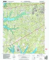
2002 Map of New Hill
USGS Topo · Published 2004About this map
The boundary line of Chatham Co Wake Co bisects a landscape defined by significant water management and energy infrastructure at the turn of the millennium. To the south, the massive Shearon Harris Reservoir and its associated Power Plant dominate the terrain, while the northern edge is marked by the expansive reach of B Everett Jordan Lake. These modern reservoirs contrast with the established rural character of the area, where smaller settlements like New Hill, Bonsal, and Friendship remain anchored by local landmarks.
Find a feature on this map
30 named features on this map. Tap any name to fly to it.
Don’t see what you’re looking for? This feature index may not catch every label — zoom into the map to look around manually.
Map Details
Editions of this 2002 New Hill Map
This is the sole edition of this map. No revisions or reprints were ever made.
Other maps of this area

1943 · Durham South
USGS Topo · 1:62,500

1951 · Farrington
USGS Topo · 1:24,000

1951 · Durham South
USGS Topo · 1:62,500

1953 · Raleigh
USGS Topo · 1:250,000

1954 · Raleigh
USGS Topo · 1:250,000

1969 · New Hope Dam
USGS Topo · 1:24,000

1970 · Moncure
USGS Topo · 1:24,000
1973 · Cary
USGS Topo · 1:24,000
1973 · Green Level
USGS Topo · 1:24,000

1974 · Apex
USGS Topo · 1:24,000