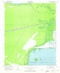
1951 Map of New Lake SE
USGS Topo · Published 1972About this map
Mattamuskeet National Wildlife Refuge dominates the southern portion of this landscape, where the northern waters of Lake Mattamuskeet meet a complex network of drainage and transport infrastructure. The area is defined by the rigid geometry of the Intracoastal Waterway Alligator River-Pungo River Canal, a critical artery for coastal shipping that cuts through the wetlands. This 1950s survey captures the region's managed hydrology, showing how the Florida Canal and Swindell Canal provide drainage for agricultural or conservation purposes between New Lake and the larger lake to the south. Near the waterway, noted ruins suggest earlier structures or industrial activity along the canal banks. Natural features like New Lake Fork and Head Lake Island provide contrast to the engineered landscape, illustrating the intersection of wild swamp and human-led water management in eastern North Carolina.
Find a feature on this map
18 named features on this map. Tap any name to fly to it.
Don’t see what you’re looking for? This feature index may not catch every label — zoom into the map to look around manually.
Map Details
Editions of this 1951 New Lake SE Map
4 editions found
Other maps of this area

1943 · Columbia
USGS Topo · 1:125,000

1951 · Scranton
USGS Topo · 1:24,000

1951 · New Holland
USGS Topo · 1:24,000

1951 · Swanquarter
USGS Topo · 1:24,000

1951 · Fairfield
USGS Topo · 1:24,000

1951 · Ponzer
USGS Topo · 1:24,000

1951 · New Lake SE
USGS Topo · 1:24,000

1953 · Fairfield NW
USGS Topo · 1:24,000

1953 · Rocky Mount
USGS Topo · 1:250,000

1954 · Rocky Mount
USGS Topo · 1:250,000