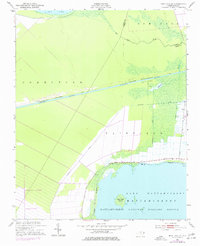
1951 Map of New Lake SE
USGS Topo · Published 1977About this map
Mattamuskeet National Wildlife Refuge anchors the southern portion of this coastal landscape, protecting the northern reaches of Lake Mattamuskeet and Head Lake Island. The terrain is defined by an extensive drainage network, where the engineered Intracoastal Waterway Pungo River-Alligator River Canal cuts a straight line across the center of the sheet, bridging the Alligator River and Pungo River systems. This mid-century survey illustrates the intricate water management of the region, specifically in the township of Fairfield, where numerous secondary channels like Swindells Canal and Florida Canal segment the low-lying plains. To the north, the boundary between Hyde and Tyrrell Counties crosses the waters of New Lake, while the township of Gum Neck occupies the northeastern corner, highlighting the area's transition from open water to reclaimed wetlands.
Find a feature on this map
19 named features on this map. Tap any name to fly to it.
Don’t see what you’re looking for? This feature index may not catch every label — zoom into the map to look around manually.
Map Details
Editions of this 1951 New Lake SE Map
4 editions found
Other maps of this area

1943 · Columbia
USGS Topo · 1:125,000

1951 · Scranton
USGS Topo · 1:24,000

1951 · New Holland
USGS Topo · 1:24,000

1951 · Swanquarter
USGS Topo · 1:24,000

1951 · Fairfield
USGS Topo · 1:24,000

1951 · Ponzer
USGS Topo · 1:24,000

1951 · New Lake SE
USGS Topo · 1:24,000

1953 · Fairfield NW
USGS Topo · 1:24,000

1953 · Rocky Mount
USGS Topo · 1:250,000

1954 · Rocky Mount
USGS Topo · 1:250,000