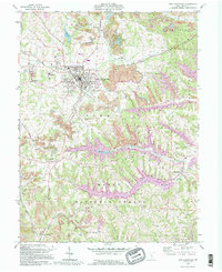
1992 Map of New Lexington
USGS Topo · Published 1995About this map
The county seat of New Lexington serves as the industrial and civic anchor for this part of Perry County, surrounded by a landscape defined by resource extraction and early educational institutions. The map details the prominent St Aloysius Academy and the local Fairgrounds, while the surrounding hills of Clayton and Pike townships are marked by extensive strip mines and scattered gas wells. These features illustrate the deep-seated connection between the local economy and the region's geology.
Find a feature on this map
69 named features on this map. Tap any name to fly to it.
Don’t see what you’re looking for? This feature index may not catch every label — zoom into the map to look around manually.
Map Details
Editions of this 1992 New Lexington Map
This is the sole edition of this map. No revisions or reprints were ever made.
Other maps of this area

1907 · Logan
USGS Topo · 1:62,500

1909 · Thornville
USGS Topo · 1:62,500

1909 · Logan
USGS Topo · 1:62,500

1910 · Zanesville
USGS Topo · 1:62,500

1911 · New Lexington
USGS Topo · 1:62,500

1947 · Columbus
USGS Topo · 1:250,000

1961 · Columbus
USGS Topo · 1:250,000

1961 · Corning
USGS Topo · 1:24,000

1961 · New Lexington
USGS Topo · 1:24,000

1961 · Deavertown
USGS Topo · 1:24,000