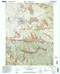
2002 Map of New Lexington
USGS Topo · Published 2006About this map
The industrial and natural landscape of Perry County is centered around New Lexington, where the urban grid is flanked by the Conrail rail line and local landmarks like the Fairgrounds and St Aloysius Academy. The surrounding terrain reflects a complex history of land use, with extensive Mine workings and Strip Mine operations scattered through the hills between Rush Creek and Bear Run. South of the city, the landscape transitions into the preserved timber of the Wayne National Forest and Perry State Forest, carved by the distinct ridgelines of Bristol Ridge and Skinner Ridge.
Find a feature on this map
47 named features on this map. Tap any name to fly to it.
Don’t see what you’re looking for? This feature index may not catch every label — zoom into the map to look around manually.
Map Details
Editions of this 2002 New Lexington Map
This is the sole edition of this map. No revisions or reprints were ever made.
Other maps of this area

1907 · Logan
USGS Topo · 1:62,500

1909 · Thornville
USGS Topo · 1:62,500

1909 · Logan
USGS Topo · 1:62,500

1910 · Zanesville
USGS Topo · 1:62,500

1911 · New Lexington
USGS Topo · 1:62,500

1947 · Columbus
USGS Topo · 1:250,000

1961 · Columbus
USGS Topo · 1:250,000

1961 · Corning
USGS Topo · 1:24,000

1961 · New Lexington
USGS Topo · 1:24,000

1961 · Deavertown
USGS Topo · 1:24,000